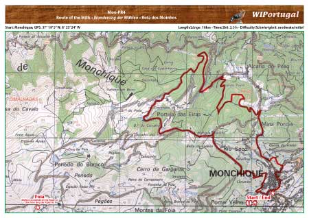
Hike Monchique MCQ PR 4 - Route of the Mills
Hike in the green hills north of Monchique, with visits of various mill installations.
Start: Monchique, GPS: 37° 19' 5" N / 8° 33' 24" W- Google Map
Length: 10 km
Duration: 2h
Anfahrt: From the motorway A22 Exit Monchique and drive towards Monchique. The hike starts in the centre of Monchique. Easy parking in the parking garage at the tourist information.
Map: Free Map (pdf format) Download including the track.
Costs Map and Track: The maps are free to download. However, we ask for a Donation of 0,50 Euro (or any higher amount!). This allows us to keep our team happy who create and update these maps.
You can donate simply with paypal: