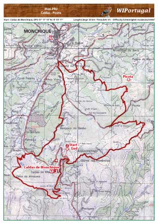
Hike Monchique MCQ PR 2 - Caldas-Picota
Hike in the hills of Monchique. From the Spa Town of Caldas de Monchique to Picota, the second highest mountain in the Algarve.
The route is marked.
Start: Caldas de Monchique, GPS: 37° 17' 10" N / 8° 33' 11" W- Google Map
Length: 20 km
Duration: 5h
Access: From the motorway A22 Exit Monchique and drive towards Monchique. At the second sign Caldas turn to the left and park in Caldas.
Map: Free Map (pdf format) Download including the track.
Costs Map and Track: The maps are free to download. However, we ask for a Donation of 0,50 Euro (or any higher amount!). This allows us to keep our team happy who create and update these maps.
You can donate simply with paypal: