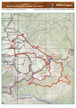
Hike Loule PR13 - Mountains and Hills
Hike in the valley of Querença, with numerous springs along the way.
Start: Corte Garcia, GPS: 37º 12' 3"N / 7° 58' 22" W - Google Map
Length: 10,4 km
Duration: 3h 30min
Way marked
Note: Parking at the starting Point
Anfahrt: From the motorway A22 exit Loule. Drive through Loule following the signs Querença/Barranco do Velho. Continue until the small village Corte Garcia. At the end of the village there is a small picnic area to the left where the trail starts.
Tracks: Track as GPX file available. The Track comes together with the Map.
Map: Free Map (pdf format) and Track Download.
Costs Map and Track: The maps are free to download. However, we ask for a Donation of 0,50 Euro (or any higher amount!). This allows us to keep our team happy who create and update these maps.
You can donate simply with paypal: