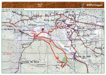
Hike Loulé 14 - Salir
Hike from Salir along various Irrigation Mills.
Start: Salir, GPS: 37° 14' 24" N / 8° 2' 54"W - Google Map
Length: 6 km
Duration: 2 h
Note: This trail passes various old water mills. Picnic area along the way.
Access: From the motorway A22 exit Loulé. Continue towards Salir following the signs.
Tracks: Track as GPX file available. The Track comes together with the Map.
Map: Free Map (pdf format) and Track Download.
Costs Map and Track: The maps are free to download. However, we ask for a Donation of 0,50 Euro (or any higher amount!). This allows us to keep our team happy who create and update these maps.
You can donate simply with paypal: