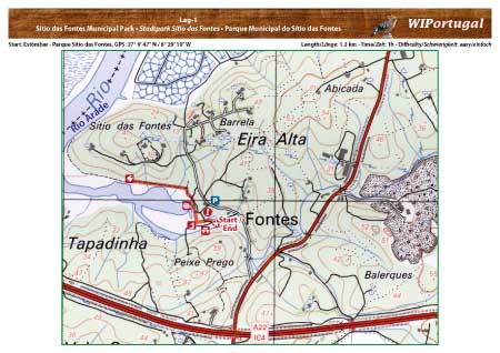
Hiking Trail Lagoa 1 - Sítio das Fontes Municipal Park
Short Stroll in the public park Sítio das Fontes.
Start: Parque Sítio das Fontes, GPS: 37° 9' 47" N / 8° 29' 10" W- Google Map
Length: 1,3 km
Duration: 1 h
Access: From the motorway A22 Exit Silves. At the sign "Estação Silves" turn in the direction of the train station. Continue at the roundabout towards Estômbar. Turn off to the rigth to the park.
Map: Free Map (pdf format) Download.
Costs Map and Track: The maps are free to download. However, we ask for a Donation of 0,50 Euro (or any higher amount!). This allows us to keep our team happy who create and update these maps.
You can donate simply with paypal: