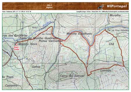
Hike Albufeira 3 - Algibre
Hike along the Algibre River. Nice small trail through the vegetation along the river.
No markings along the trail.
Start: near Paderne, GPS: 37° 11' 0"N / 8° 10' 6" W- Google Map
Length: 16 km
Duration: 4h
Note: do not walk on hot days.
Approach: From the Motorway A22 Exit Albufeira. Follow the Signs towards Ferreiras and then towarts Paderne. There turn left and drive eastwards, with the River on your left.
Tracks: Track as GPX file available. The Track comes together with the Map.
Map: Free Map (pdf format) and Track Download.
Costs Map and Track: The maps are free to download. However, we ask for a Donation of 0,50 Euro (or any higher amount!). This allows us to keep our team happy who create and update these maps.
You can donate simply with paypal: